The Pacific looks like 1997 in NASA’s new El Niño comparison. The weather need not repeat
Satellite sea-height measurements reveal a striking similarity across decades. They are evidence of ocean conditions, not a local winter forecast.
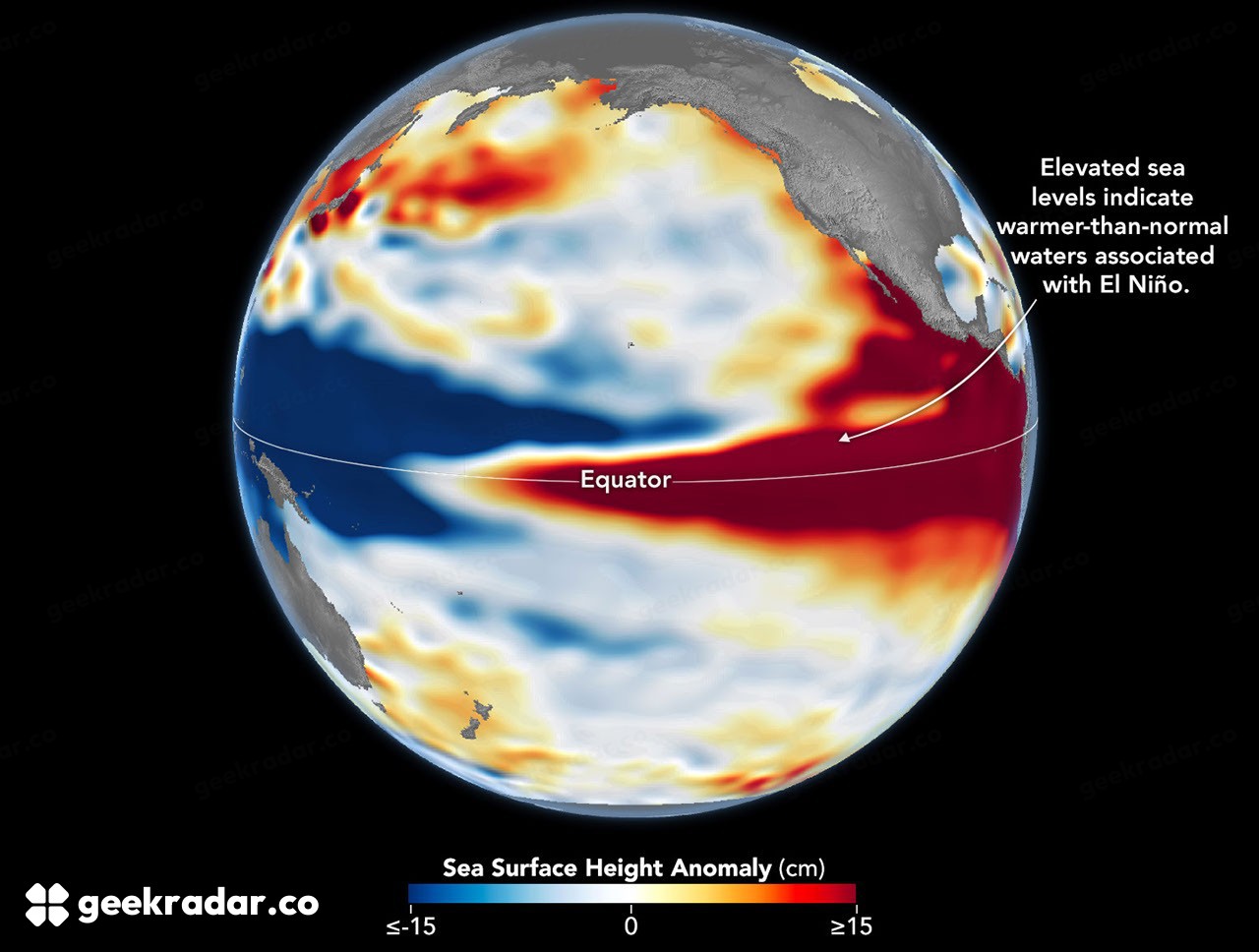
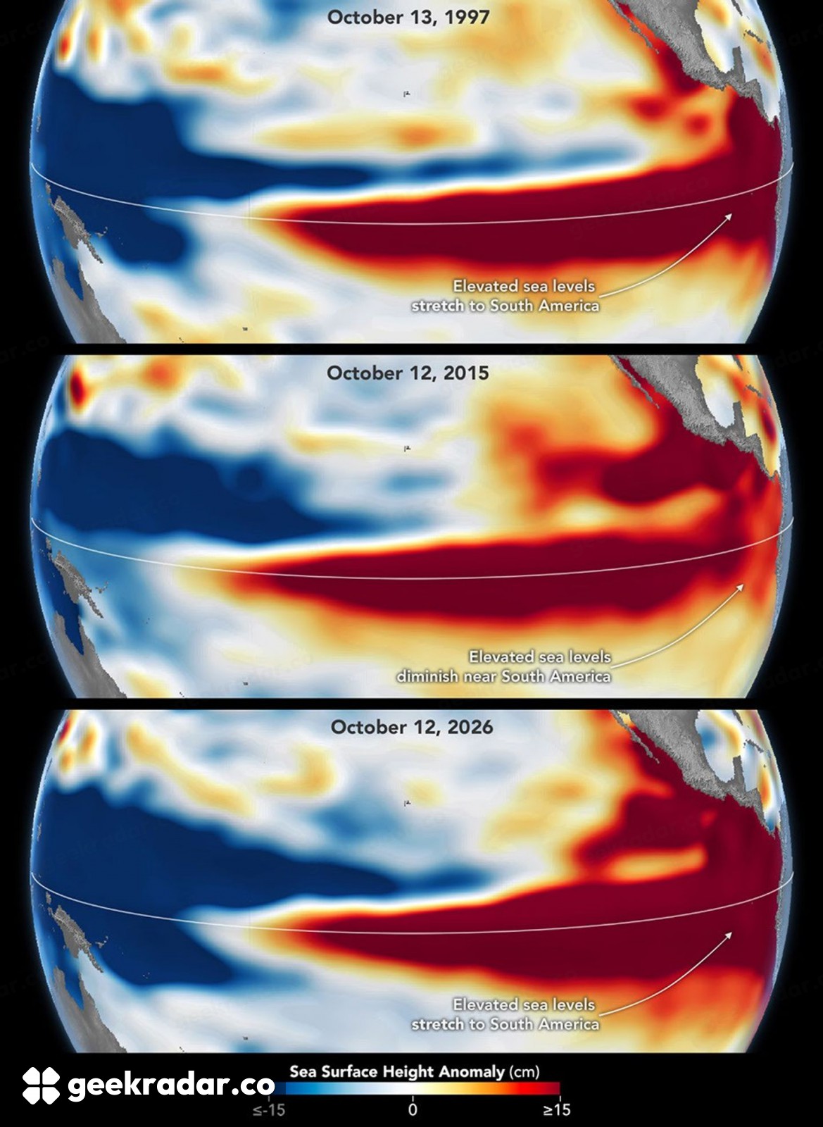
NASA's new comparison of the Pacific shows a familiar shape: elevated sea levels stretching across the equator toward South America, resembling the pattern during the powerful 1997–98 El Niño. The resemblance is useful evidence about the ocean. It is not a promise that the same places will experience the same weather this winter.
The Earth Observatory comparison pairs observations from October 1997 and October 2026 and places them alongside 2015. The maps measure sea-surface height anomalies. Their red areas show water standing higher than the reference level, rather than a direct picture of air temperature or a map of where flooding will occur.
Why the height of water reveals heat
Water expands as it warms. Across a large ocean, the resulting change in height helps satellites track the distribution of heat below the surface. Winds also redistribute water, so the pattern reflects a connected ocean-atmosphere system rather than a thermometer placed at every point.
During El Niño, changes in the trade winds allow warm water to move eastward across the equatorial Pacific. The ocean and atmosphere reinforce one another. That is why the location and extent of the warm water matter alongside the strength of a single temperature index.
The comparison also depends on continuity between missions. The 1997 and 2026 observations come from different satellites, but a long, overlapping altimetry record gives researchers a way to compare them. The achievement is not just taking a new picture; it is maintaining measurements that remain interpretable decades apart.
Similar strength does not mean identical geography
NASA's three-year comparison illustrates the point with 2015. That event was also very strong, but the high-water pattern did not extend against South America in the same way. A single label such as strong El Niño can therefore conceal differences in where the ocean's heat is concentrated.
The October 8 NOAA discussion assigns a high probability to a strong-to-very-strong event continuing through January–March 2027. That is a forecast about the large-scale climate state. NOAA explicitly distinguishes increased chances of characteristic impacts from a guarantee that those impacts will happen.
Atmospheric circulation is not a photocopier. A similar Pacific pattern can influence the odds of rainfall or temperature outcomes while interacting with other conditions. Treating a historical comparison as a city-by-city forecast would claim more than either the map or the outlook supports.
What this means for an Italian reader
The Pacific matters internationally because changes there can influence circulation and connected systems far beyond its coast. That makes the observation relevant to Europe. It does not allow a direct conclusion that Italy will have a particular kind of winter, or that a specific storm should be attributed to this map alone.
For local decisions, regional forecasts remain the appropriate evidence. The satellite comparison answers a different question: how unusual the present ocean state is, and which earlier events offer useful points of reference. Our climate coverage keeps those scales separate.
The striking part of the image is the resemblance across 29 years. The scientifically useful part is the ability to measure both the resemblance and the differences. A red band across the Pacific changes the odds; it does not write the winter's itinerary.