NASA’s CASALS lidar fills the space between the tracks. The next step is still airborne
A newly published report explains wavelength steering and forest measurements from a 2024 flight. A space-ready instrument remains future work.
NASA has published a closer look at a lidar instrument designed to fill the gaps between narrow laser tracks on maps of Earth. CASALS steers its measurements by changing the wavelength of light, rather than moving a scanning mirror. The October 21 report describes an airborne prototype and a route toward future space hardware; it is not an announcement that a new mapping satellite has entered service.
The distinction does not make the result less interesting. A line of accurate measurements can tell a researcher a great deal about a forest. A continuous strip can reveal how that structure changes between the lines. CASALS is aimed at that difference in coverage.
Change the wavelength, change the direction
Lidar measures distance using reflected light. NASA's earlier explanation of the technology describes the familiar timing principle: send a pulse, measure its return, and infer distance. Repeating the process across a landscape builds up information about its shape.
The difficult part is collecting enough neighboring measurements without making the instrument too heavy or power-hungry. CASALS uses a tunable laser and an optical grating. Different wavelengths leave the grating at different angles, allowing the instrument to address different positions across its path.
The team's technical paper explains the architecture behind the airborne system, including 256 contiguous ground positions and a wavelength-tuned transmitter near 1,040 nanometers. Those details describe the instrument's scanning method. They should not be confused with a promise that every future mission will deliver identical coverage or resolution.
The forest image contains more than a canopy
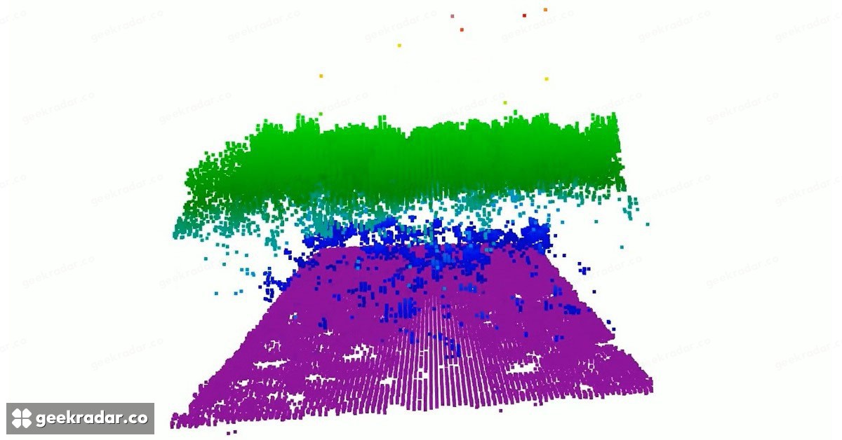
NASA's new report includes measurements from a November 12, 2024 flight over Delaware's Great Cypress Swamp. In the visualization, green marks canopy tops, purple the ground and blue vegetation nearer the ground. The colors encode measured structure; they are not the landscape's natural colors.
That separation is the useful thing to notice. A conventional overhead photograph can make a forest look like a continuous roof. A three-dimensional measurement can distinguish returns at different heights, helping researchers examine the relationship between vegetation and terrain. The image's value lies in those layers, not in how much it resembles a photograph.
The reported airborne campaign used NASA's B200 King Air. Its age also matters: the flight happened in 2024, while this account of the results and next steps was published in October 2026. Treating the publication date as the date of the experiment would invent a more immediate milestone than the evidence supports.
An aircraft demonstration is one stage of the work
NASA plans another CASALS flight for the ASCENT campaign in summer 2027, with wider coverage and onboard processing among the improvements needed before a space-ready prototype. The ASCENT overview places airborne measurements in a broader program combining radar, lidar and stereo imaging to study future observing systems.
These instruments provide different kinds of information. Bringing their measurements together can help researchers understand what a proposed observing system would actually resolve, rather than judging it by one attractive reconstruction. A successful flight is evidence about an instrument in a particular setting; orbit adds another set of constraints.
For readers following NASA, CASALS is a useful example of progress before launch. The immediate achievement is a way to collect more connected measurements of a landscape. If the technology reaches space, its most important contribution may be the terrain scientists no longer have to infer between the tracks.