Why Everest disappears in a photo that shows 1,000 kilometres of the Himalayas
Two astronauts used 16 mm and 420 mm lenses on separate passes. A pair of valleys helps locate the summit in the closer view.
The Himalayas are easy to spot from the International Space Station. Everest is another matter. Canadian astronaut Joshua Kutryk shared photographs of the range on November 17. When Space.com featured them on Friday, it couldn’t pin down exactly which part of the mountains they showed. It’s tempting to pick the most conspicuous white peak. Two earlier ISS photographs show why that would be a guess, and how to make a better identification.
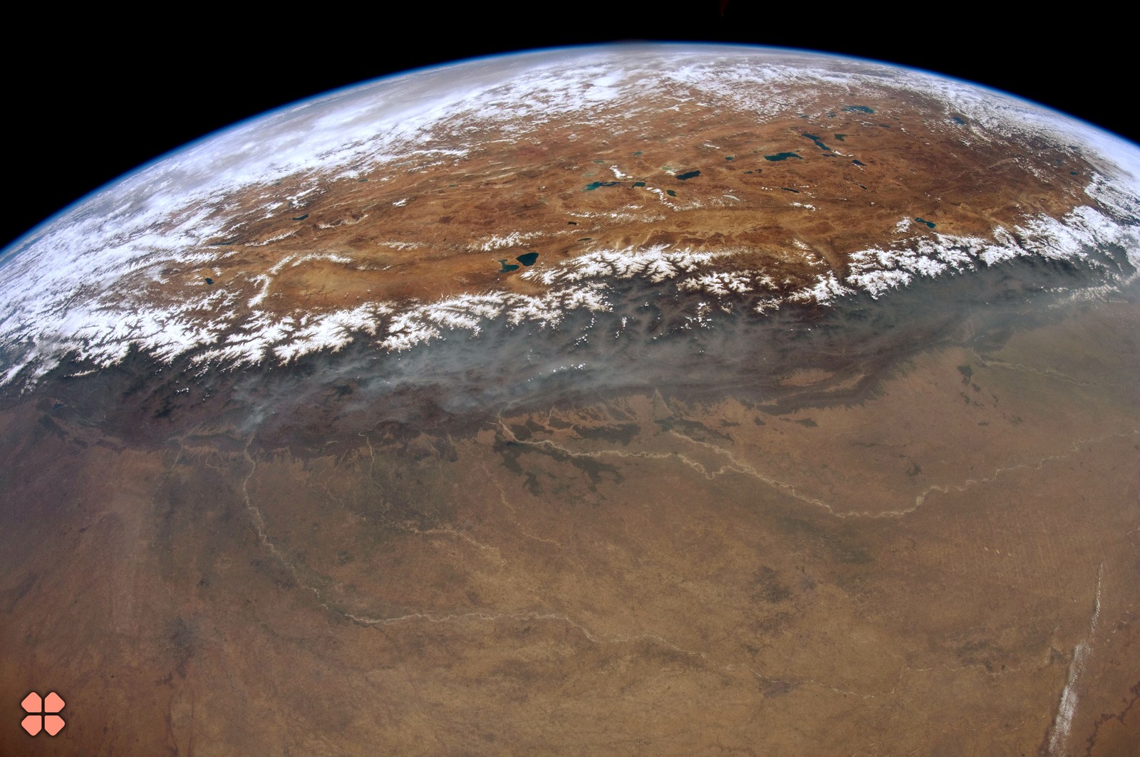
Start with Don Pettit’s photograph at the top of this page. Taken on May 23, 2012, it gathers roughly 1,000 kilometres of the Himalayan chain into one frame. The band of snow separates the Ganges plain in the foreground from the brown Tibetan Plateau beyond. Farther back, the blue edge of the atmosphere follows Earth’s curve. It’s an excellent picture for seeing where a mountain range begins and ends. NASA says Everest itself is indistinguishable in this panoramic view.
What the longer lens gives you
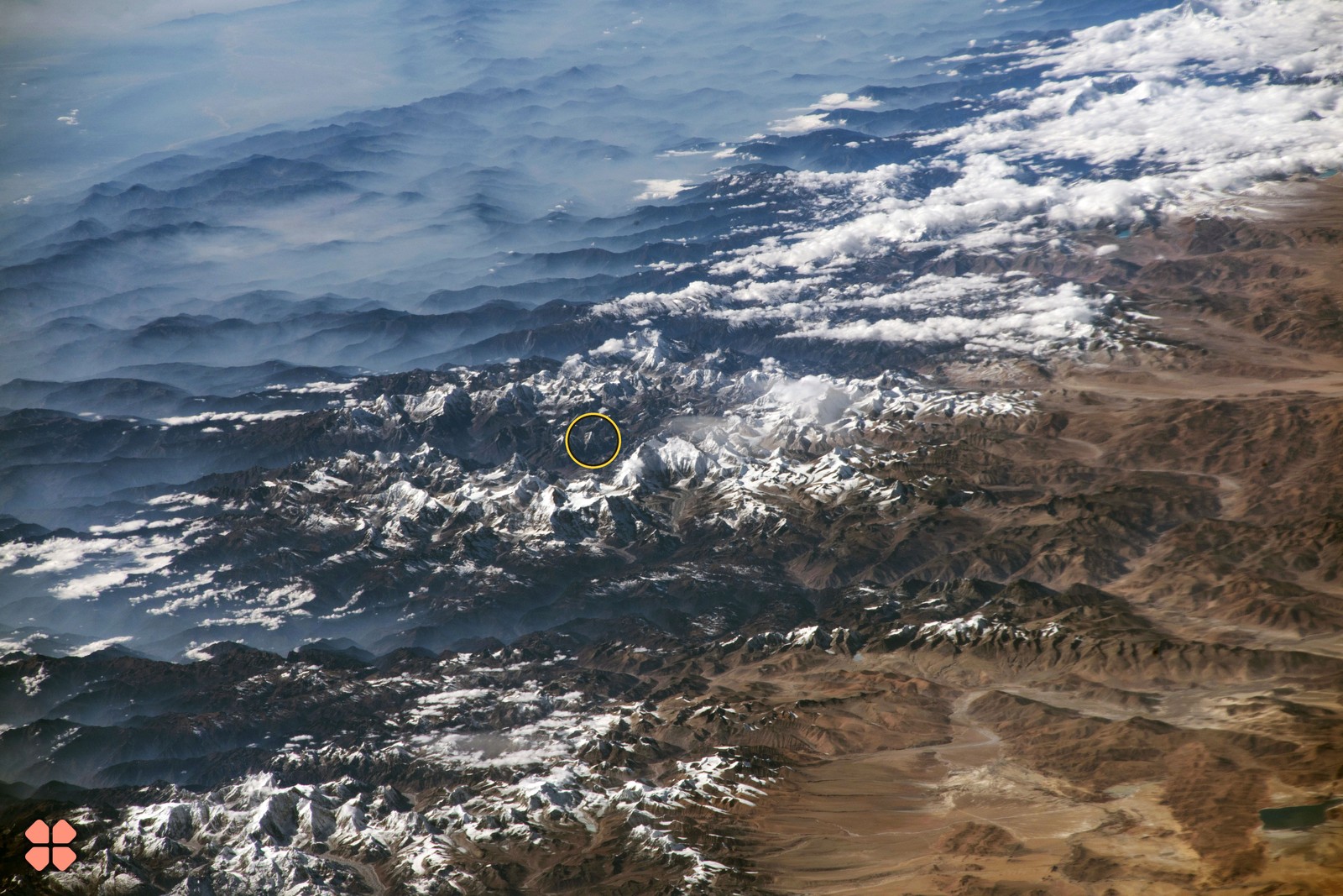
Pettit used a 16 mm lens. On December 5, 2017, Randy Bresnik looked southwest from the station with a 420 mm lens. The two photographs were made on different passes, with different cameras and viewing directions. Enlarging Pettit’s image would make its pixels bigger. Bresnik’s camera actually recorded detail across a narrower patch of terrain. In his photograph, the yellow circle encloses the summit NASA identifies in its labeled version of the same exposure.
The mountain sits among its neighbours, well inside the frame. At 8,848.86 metres above sea level, Everest leads a ranking whose reference surface lies far below anything visible around the summit. The photograph gives you a different comparison: one sunlit face beside another, viewed at an angle, with intervening ridges partly hiding the slopes behind. The point nearest the top edge of a picture has no special claim to be the point farthest above sea level.
A better way in is to follow the gaps. Two major valleys cut through the range on either side of Everest. NASA notes that on the day Bresnik took the picture, winds from the south carried cloud up some of the valleys towards the plateau. Those white streamers are useful for tracing the breaks in the terrain. Following the shape of the valleys and neighbouring ridges gives you several features to match against a labeled view. The amount of snow on a single summit gives you just one, and an unreliable one at that.
Turn the view straight down
A December 2021 photograph supplies a further check. Taken with a 400 mm lens pointed almost straight down, it shows Everest with hardly any of the familiar skyline effect. Glaciers run away from the high peaks. Lower down, some of their ice disappears under rock debris. With the horizon gone, the branches of a glacier and the bend of a valley can be easier to follow than a summit’s outline.
Light changes the reading again. In an early-morning frame from March 2002, the low Sun lights Everest’s eastern Kangshung Face and brings its relief into view. As with the exposure that revealed Jupiter’s ring, what you can recognize depends on the geometry of the photograph. Look back at Pettit’s panorama after finding Everest in Bresnik’s frame. The feature that stands out across all those kilometres is the snowy seam between plain and plateau. Even the world’s highest summit can disappear inside it.